weaponised boulders and uprooted timber, completely altered the local river morphology / LBH Padang archives")
Victims of the Sumatran floods refuse to accept engineered ecological collapse
I took a deep sigh of relief after unloading the last two boxes of mineral water from the aid truck. It was then that the woman whose house we used as a temporary logistics post approached me.
‘Do you have any blankets or underwear, son?’ she asked.
She was covered in grime, looking just like someone who had just participated in the neighbourhood competitions traditionally held on Independence Day. Except the dirt on her body was neither flour nor field dust. It was mud, the thick, toxic mud that had breached her home during the flash floods two days prior. I estimated her age to be close to my own mother’s.
‘We don't have them right now, ma'am,’ I replied. ‘But we will buy some and bring them to you this afternoon.’ Her house, like many others around her, barely looked like a home anymore.
What sticks with me most from those days is the smell. I was standing in Batu Busuak Village, Padang, a ground-zero location ravaged by the late 2025 Sumatra flash floods. This area is near my alma mater, Andalas University, so I know it well. Yet, on that day, it was unrecognisable. I no longer caught the fresh, earthy scent of rain from the Barisan Hills. Instead, the air was heavy with an acrid, suffocating blend of waterlogged timber and soil brutally torn from the earth. Upstream, the heartwood of the trees glowed a fiery red where they had been violently ripped from their roots.
At various points, the rivers no longer follow their original courses, appearing like gaping wounds carved into the earth. I encountered ‘wild’ rivers slicing a local mosque in two, flowing straight through a classroom, and tearing away residents' front porches. The houses stood fragile, like sodden cardboard boxes, while boulders the size of excavators lay scattered across what were once picturesque yards.
I was not a direct victim, my family was safe. Yet, walking through the debris, it became impossible to believe this catastrophe was solely an act of God. In West Sumatra, rain is a familiar old friend, not a death sentence. Accepting this as mere climate-driven fate leaves us powerless. A deeper look reveals that this tragedy is a man-made crisis born of structured spatial negligence.
Vanishing forest fortresses
The Indonesian government routinely deploys a standard bureaucratic shield when responding to socio-ecological disasters: pointing to the sky. They blame ‘unprecedented climate anomalies’ or extreme rainfall to mask decades of catastrophic spatial planning failures, invoking force majeure to wash their hands of legal liability.
I refuse to accept that the state is merely a helpless victim of shifting weather patterns. To confront this institutional incompetence, I conducted a rigorous spatial audit across the entire island. As illustrated in the spatial transition mapping (see below), data from the MapBiomas Indonesia platform tells a grim tale of engineered ecological collapse.
Since 1990, Sumatra has lost an astronomical 9,190,618 hectares of forest cover. In less than three and a half decades, the island's natural forest plummeted from 23.9 million hectares to just 14.7 million hectares in 2024, a staggering average loss of over 270,000 hectares annually.
Spatiotemporal transition animation of Sumatra’s forest cover (1990–2024) compiled from MapBiomas Indonesia, illustrating the systematic, long-term hollowing out of primary forest fortresses across the island.
This macro-regional erosion explains why the late 2025 flash floods inflicted an extraordinary toll across three provinces simultaneously: Aceh, North Sumatra and West Sumatra. The natural infrastructure designed to absorb heavy rainfall had been systematically dismantled from within.
Let us now look only at northern Sumatra, where extreme rainfall triggered devastating floods in November last year. Over these three decades, North Sumatra’s forests shrank by over 1.1 million hectares, severely undermining the region's natural capacity to mitigate climate shocks and maintain watershed stability. In West Sumatra, atop the fragile Bukit Barisan ridge, forest cover dropped from 2.3 million to 1.9 million hectares. Meanwhile, Aceh, long romanticised as Sumatra’s last pristine wilderness, saw its 4.06 million hectares of primary forest systematically punctured, losing nearly 700,000 hectares of dense canopy.
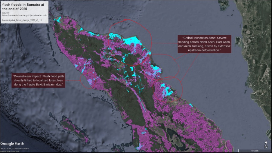
When I overlaid the geographic coordinates of the late 2025 flash floods onto this spatial transition map (see above), the illusion of a purely natural disaster vanished. The floodwaters (shaded in light blue) did not overflow randomly. Instead, the data reveals a direct causal correlation. As documented in the composite mapping, the heavily inundated zones, devastating the lowlands of North Aceh, East Aceh and Aceh Tamiang, are situated directly downstream from the massive, contiguous swathes of deforested land (shaded in pink) that have systematically punctured the upstream catchment areas. By tracing these compromised hydrological corridors from the denuded ridges down to the saturated coasts, the catastrophe shifts from an unpredictable act of God into a highly predictable consequence of upstream forest clearance.
Monopolies and marginalised farmers
Where did Sumatra’s 9.1 million hectares of lost forest go? The answer lies in a deliberate, state-sanctioned transition toward large-scale corporate agribusiness. Spatial analysis from the MapBiomas Indonesia platform, utilising official geographic data from the Indonesian Ministry of Environment and Forestry’s SIGAP portal, reveals that aggressive commercial palm oil expansion drove this historic deforestation. Between 1990 and 2024, Sumatra's palm oil area skyrocketed from 1.06 million hectares to over 6.22 million hectares.
This monoculture shift fundamentally alters the island's hydrology. Unlike the complex, multi-layered canopy of primary rainforest, which acts as a natural sponge, palm oil plantations possess significantly lower rainfall interception capacities. Furthermore, the intensive land clearing and heavy machinery inherent in corporate plantation development cause severe soil compaction. This process drastically reduces the ground's infiltration rates, forcing heavy rainfall to immediately transform into high-velocity surface runoff rather, than absorbing into the aquifers. What was once a dense stronghold of primary forest has been systematically sacrificed for industrial agriculture.
Ironically, this rapid agricultural expansion never fostered an equitable distribution of agrarian wealth among the people of Sumatra. The latest agricultural census data (ST2023) from the Indonesian Central Statistics Agency (BPS) exposes extreme land inequality across these disaster epicentrism zones. In North Sumatra, smallholder farmers—meaning vulnerable subsistence farmers holding less than half a hectare of land—comprise a staggering 99.94 per cent of all individual farming units. Yet, they are increasingly marginalised, collectively holding a cumulative total of merely 151,000 hectares of land. In stark contrast, only 432 large-scale corporate entities in North Sumatra hold state concession permits, or Rights to Cultivate (HGU), controlling over 1.3 million hectares of productive land. A similar crisis occurs in West Sumatra, where smallholder farmers comprise 99.98 per cent of individual farming units, squeezed into only 18 to 21 per cent of the available land, while a mere 96 corporate entities control up to 380,000 hectares of fertile territory.
Meanwhile, Aceh Tamiang Regency, one of the areas most severely impacted by the disaster, presents a harrowing case study. Its entire administrative territory lies squarely within the massive Tamiang River Basin, which spans 498,278 hectares. Over the past three decades, this basin sustained a cumulative forest loss of 33,467 hectares. As illustrated in the three-dimensional spatial visualisation (see below), the Tamiang River Basin is shaped like a giant funnel, emptying east-northeast towards the Straits of Malacca. This geomorphological structure forces all upstream drainage from the western mountainous ridges to flow eastward, converging directly into an increasingly narrow bottleneck aperture near the coast.
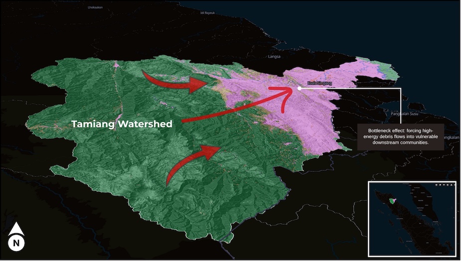
Losing natural forest canopy at the apex of this funnel triggers an exponential surge in hydrological velocity. Under compacted soil conditions and without forest root systems to delay the water, the upstream ecosystem acts as a high-energy conduit. When heavy rains struck in late 2025, surface runoff transformed into a destructive torrent of debris flows, channeling water directly toward small downstream communities. A forest loss of just 6.72 per cent, when situated within this funnel-shaped basin, was sufficient to claim 57 lives and force 262,087 people from their homes.
The economics of debris flows
Sumatra’s devastating flash floods are the direct manifestation of a collapsed ecological defense system. My recent spatial analysis, utilising Watershed (DAS) data from the Ministry of Environment and Forestry’s SIGAP portal combined with computational modelling using Google Earth Engine (GEE), exposes the precise structural mechanics behind this engineered vulnerability. The late 2025 extreme rainfall did not trigger a normal river overflow. Instead, it weaponised 102 distinct watersheds out of the 2357 on the island, transforming degraded upstream zones into high-velocity flood conduits that inundated 469,509 hectares across just three provinces.
The immediate human cost of this structural failure was devastating. According to definitive data from the official BNPB Geoportal updated in May 2026, the resulting debris flows culminated in a protracted humanitarian crisis, claiming 1207 lives, leaving 137 people missing, and displacing 183,751 homes across 54 regencies. Aceh bore the heaviest burden with 313,264 hectares submerged, followed by North Sumatra with 117,472 hectares, and West Sumatra with 38,641 hectares.
To understand how this ecological collapse translates into long-term human immiseration, one must look at the highly unequal agrarian landscape. As established by the BPS ST2023 census data, 99 per cent of local cultivators are petani gurem (farmers owning less than 0.5 hectares). Because corporate palm oil concessions control the safe, fertile plains, these subsistence farmers are systematically pushed to cultivate highly vulnerable slopes or marginal riparian zones right beneath the degraded corporate headwaters. For these families, a house and a tiny plot of land represent their entire domestic capital and sole financial safety net. When a torrent of upstream mud and boulders buries their fields, their productive assets are annihilated. This asset destruction halts any possibility of upward social mobility, forcing families to rebuild from a deep economic deficit that creates a permanent, intergenerational underclass.
The macroeconomic modelling by the Centre of Economic and Law Studies (CELIOS) captures the aggregate scale of this localised devastation. The disaster inflicted a total national economic loss of Rp.68.67 trillion (US$4.2 billion), shrinking Indonesia’s GDP by 0.29 percent, while the regional economies of Aceh, North Sumatra and West Sumatra each contracted by more than Rp.2 trillion. This multi-trillion rupiah contraction is not an abstract figure, it is the mathematical accumulation of hundreds of thousands of petani gurem losing their entire livelihoods simultaneously.
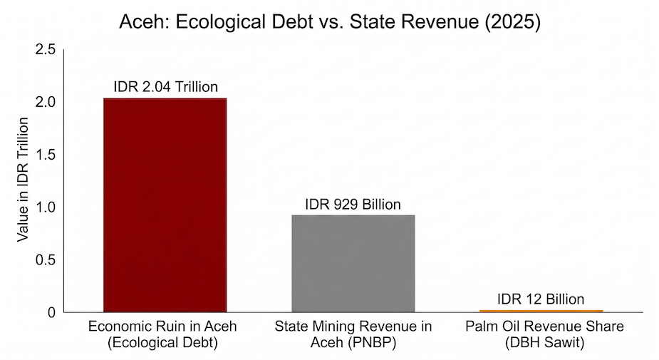
This economic ruin far outstrips any local benefits generated by the extractive economy. In Aceh, the Rp.2.04 trillion in localised economic destruction far exceeded the province's total non-tax revenue from the mining sector (Rp.929 billion), while the state-allocated Palm Oil Revenue Sharing Fund (DBH Sawit) returned a minuscule Rp.12 billion to the region.
This economic failure was further exacerbated by the critical breakdown of the government's early warning system. As reported by BMKG, institutional sluggishness left these structurally vulnerable communities completely helpless when the rivers finally breached.
The stark asymmetry of this model is highlighted in the CELIOS report Republik Oligarki, which notes that 58 per cent of the wealth held by Indonesia's 50 richest tycoons is derived directly from extractive sectors like palm oil and mining, while average workers' wages stagnate at an annual increase of only 1.94 per cent. The financial gains from this massive ecological exploitation are reaped and hoarded by corporate elites in urban centres, while the agrarian poor are left to drown beneath 469,000 hectares of floodwaters, burdened by an ecological debt left behind in the mud.
Reclaiming the state via citizen lawsuit
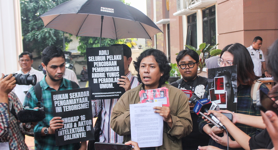
The multi-provincial inundation of 469,509 hectares of land is not a fate that the people of Sumatra are willing to accept silently. Facing systematic administrative neglect and the structural destruction of their river basins, citizens have refused to remain passive casualties of an extractive economy. On Thursday, 7 May 2026, a broad coalition of disaster survivors and civil society organisations under the Advocacy Team for Justice in Sumatra, spearheaded by YLBHI, filed a Citizen Lawsuit (CLS) at the Jakarta State Administrative Court (PTUN Jakarta). This legal action invokes Law No. 30/2014 on Government Administration, directly suing the President and the Head of the National Disaster Management Agency (BNPB) for their material failure to act, or omission, in preventing the environmental disaster.
The lawsuit exposes a profound moral and political hypocrisy in the state's post-disaster response. The government rejected demands for a National Disaster Status, claiming it would disrupt the state budget. This fiscal austerity stands in grotesque contrast to the administration's spendthrift priorities, which include allocating Rp.3.2 trillion for electric motorcycle subsidies and pouring hundreds of trillions into vanity infrastructure projects. To worsen the injury, senior officials openly downplayed the crisis, with the head of the BNPB dismissively claiming that the horrific scale of the Sumatra floods was merely ‘exaggerated on social media.’ While the state blocked international humanitarian assistance, hundreds of thousands of displaced survivors were left stranded in the mud without electricity, clean water, or communications.
Ultimately, this Citizen Lawsuit is not a plea for disaster relief funds, it is a structural manifesto aimed at dismantling the oligarchic republic entrenched on the ground. Through this legal battle, citizens explicitly charge that the collapse of the island’s hydrological defenses was directly engineered by the state-sanctioned conversion of primary rainforest sponges into compacted, low-interception corporate palm oil plantations. They demand a comprehensive spatial planning audit of all active corporate concessions, the immediate revocation of permits for commercial plantations illegally operating within upstream protection zones, and a total overhaul of the Regional Spatial Plan (RTRW) framework. Sumatra must no longer be treated as a disposable sacrifice zone, where ecological debts are permanently offloaded onto impoverished rural communities. By taking the state to court, the people of Aceh, North Sumatra and West Sumatra employ law and spatial science to reclaim their constitutional right to a safe environment, drawing a firm line in the mud to ensure their island ceases to be devastated by unchecked extraction.
Habieb Sufi (habiebsufi@lbhpadang.org) works at the Legal Aid Institute in Padang, Sumatra (Lembaga Bantuan Hukum, LBH Padang).