
Though earthquakes are common in Palu, residents underestimate the threat, and government response efforts are weak
Muhammad Nasrum
On Friday 28 September 2018 between 2pm and 3.25pm, three foreshocks occurred. At 5.9, 5.0 and 5.3 on the Richter scale, many residents did not even feel them. They were busy rushing towards the beach for Pesona Palu Nomoni, the annual festival to mark the city´s anniversary . It was Palu´s fortieth birthday. They began to crowd the coast near the bridge of Talise Beach from about 3pm onwards. Colourful banners fluttered cheerfully in the sea breeze. There were kindergarten children dressed in traditional costumes and performers rehearsing for the opening ceremony of the festival. The committee was prominent in the crowd that afternoon. Most were employees of the Palu city government, along with some security officers. Vendors of various accessories, many traveling merchants, had arranged their stalls, ready to welcome the spectators who would pour into every available space around the venue. There was no sign of anxiety that fateful afternoon.
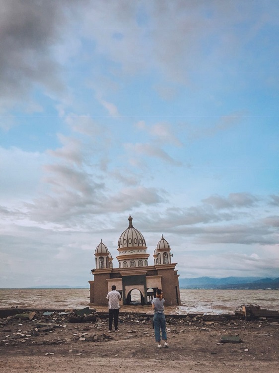
At two minutes and 44 seconds after 5pm, a fierce shaking commenced. A sound like a blaring boom came from a popular beachside viewing point known as Anjungan Nusantara. Hysterical voices rang out as the approach to the bridge alongside Talise Beach collapsed. Moments later the entire arch of Palu IV bridge – the iconic pride of Palu citizens, right at the mouth of the estuary – collapsed as well.
Between two and four minutes later, three huge tsunami waves crashed onto the shore. Some people had already run away scared from the beach. But the waves took many others who had fallen into a panicked confusion as the earth shook. They struggled to overcome the suction of the waves. As darkness fell, many lives had been lost.
Palu that night was pitch black. Electricity had gone out completely. Many city residents learned only later that a ‘supershear’ quake, tearing the earth apart at a speed of 14,760 kilometres per hour along the Palu-Koro faultline that passes right through the middle of the city, had triggered disasters no less terrible in four other locations as well.
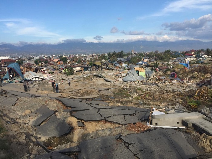
Two struck the densely populated Balaroa settlement within the Palu urban area. One of these hit the state housing complex at Perumnas Balaroa, the other a kelurahan (urban village) called Petobo. Two more occurred some distance south of Palu, at Jono Oge and Sibalaya, in the district of Sigi. All four involved a geological process known as liquefaction, a term that soon became horribly familiar to city residents. The surface of the ground moves and collapses into a porridge. All solid objects on the soil’s surface move too and are crushed and sucked into the porridge. An amateur video taken by an eyewitness on their phone shows this happening. Houses move like ships in the ocean, followed by coconut trees, plants and towers.
An estimated 4340 people died from the combined earthquake, tsunami, soil liquefaction, landslide and downlift. It was the deadliest earthquake in the world in 2018, surpassing the death toll of 563 in the Lombok earthquake on 5 August, the month before. It was Indonesia´s deadliest earthquake since Yogyakarta in 2006.
Poorly handled
Disasters in Central Sulawesi are a complex story. On one hand the multiple hazards have been discussed frequently in media and scientific circles. On the other hand, mitigation efforts have always been weak. As a consequence, city residents living on the very active Palu-Koro fault tend to underestimate the threat of earthquakes. When a disaster does occur, the aftermath is poorly handled.
Fear and panic swept through the region´s small towns immediately after the recent earthquake. Paranoia was triggered by fake news circulating everywhere by word of mouth, as well as through social media. People shared these stories around even as their devices were struggling amid power outages and weak signal.
For the first three days, Palu was totally paralysed. Basic needs such as water, electricity and fuel were very difficult to obtain. Food was sold only by a few retail stores and street vendors, who saw their chance to earn a fortune in difficult times. Shopping malls, mini markets and warehouses became open targets for violent mobs looking for food. Looters also took the opportunity to take everything from electronic equipment and tires to car engines that were left piled up in disarray. They stole property from homes left behind by residents and even broke into ATMs.
A general lack of understanding only added to complications. People naively began to demand answers, not only about what caused the disaster, but also about who was most responsible for the thousands of casualties. Masses of people began to mobilise, often identifying as religious groups, and local political movements. Rallies were answered with counter-actions. As the ‘hot’ months before the Indonesian general elections approached, residents who were still grieving grew increasingly vulnerable to the city´s pre-existing social frictions.
Just how trying life remains can be clearly seen in the refugee emergency tents that still litter all affected areas of Central Sulawesi. At the time of writing, tens of thousands of families are estimated to be still living in refugee shelters. Some temporary shelters, popularly known as Huntara, were erected long ago yet most residents, whether because they have no alternative or by choice, are still living in makeshift tents. Many Huntara blocks have not been connected to clean water and electricity. Some people consider them useless buildings, and a waste of budget. They demand new permanent housing. Others are reluctant to leave their land, where they can make a living. In mid-January, thousands of residents protested against the Huntara, demanding that permanent housing be built where their original homes stood. They criticised the shelter construction process for taking too long, saying they had been living in refugee camps for three months without receiving clarity about when they would get a shelter.
The low level of community participation was another important feature of post-disaster handling, both during the emergency response period and the transition to recovery. Community members often took their own initiatives, no longer wanting to wait for government promises that they considered vague and taking too long to materialise.
This was ironic, because the government did in fact have a budget for rehabilitation and reconstruction. But the resources came from the central government in Jakarta, which tended to take a project approach to the issue. Whether intentionally or not, the politics around handling this budget seemed to get dragged into the national political agenda. The governor of Central Sulawesi was a member of political parties that were challenging President Jokowi in the elections. He found he had limited authority to manage the disaster budget.
Meanwhile, Jokowi, apparently due to political considerations, gave an expanded role to the army. It is undeniable that the presence of the army was needed in the early days of the emergency response phase. This was also justified by regulations. But, by extending the role of the army beyond the early days, he deprived many civilians of the opportunity to earn money from the rehabilitation budget – money they desperately needed. This only added to the list of problems Central Sulawesi faced.
A history
People here have actually been familiar with earthquakes as a natural phenomenon for a very long time. Earthquakes in the central part of Sulawesi have been recorded since the eighteenth century. Some have been of large magnitude. Tsunamis have also been common. An earthquake in 1927 triggered a tsunami 15 metres high in Palu Bay. Mapaga, on the west coast of nearby Donggala, saw a 10-metre tsunami in 1968. Simuntu-Pangalaseang, also in Donggala, had a tsunami ranging from one to three metres high in 1996.
The Palu-Koro fault was first described by a team of Dutch geologists and geographers in 1909-1910. Their report ran to nearly 2000 pages. They realised that the ‘Fossa Sarasina’ fault, later known as Palu-Koro, had caused large earthquakes in the highlands and Palu valley. The report’s author, EC Abendanon, described a countryside broken into multiple blocks that continually move and grind into each other along the fault line.
More recent research conducted over the last 10 years by Mudrik R Daryono from the Indonesian research institute LIPI has created a detailed picture of the very active Palu-Koro fault. He and his team recovered evidence of many historical earthquakes. By excavating 15 to 20 metres into the ground, Mudrik concluded that large earthquakes had occurred in 1285 and 1415. Closer to the surface, he found indications of the earthquakes of 1907 and 1909, which had been recorded by Abendanon.
Palu, and Indonesia, lie on the Ring of Fire that runs around the Pacific Ocean. Ninety per cent of the world´s earthquakes occur in this region, and 81 per cent of them are the world’s biggest earthquakes. In this region, too, there are 452 volcanoes, more than 80 per cent of all the volcanoes in the world. This accounts for the large number of such disasters in Indonesia. Yet, once again it seems that Indonesians find it easy to forget and neglect. The findings of Mudrik and his team from the Palu-Koro research expedition were hardly read at the time. The government certainly needs to improve its handling of earthquakes, but the community too must learn, rather than downplay disaster risks despite being aware of what they are sitting on. Tears and regret always arrive too late.
Muhammad Nasrum (muhammadnasrum@gmail.com) is a lecturer in Anthropology in the Social and Political Science Faculty at Tadulako University, Palu.